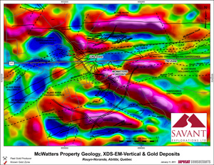
Magnetic
surveying is a geophysical method used in the mining industry to locate,
calculate and determine quantities of minerals beneath the ground. It monitors
spatial variations in the Earth's magnetic field, which allows specialists to
detect and map artifacts, features and various other formations beneath the
Earth's crust. These formations are often large deposits of minerals such as
iron, steel, brick and other form of rock that are highly magnetic.
The tools used
in magnetic surveying are called magnetometers. These scientific instruments
are tuned to measure both the strength of the magnetic field as well as the
direction. Currently, there are three different types of magnetometers used by
the mining industry to be able to detect these anomalies, and they include:
-
Gradiometers, which are pairs of meters
separated at a fixed distance horizontally. The two values are then subtracted
which provides an accurate measurement of the fields of gravity caused by
anomalies.
-
Fluxgate Magnetometers, typically consist of a
‘sense' coil and a ‘drive' coil that is wound around a core. An alternating
current is applied to the drive coil which causes both plus and minus
saturation. As there is an opposite polarity, when a magnetic field anomaly is
applied, it will aid one polarity and oppose the other.
-
Caesium Vapour Magnetometers, which consists of
a photon emitter which contains a caesium lamp, an absorption chamber
containing the vapour and a ‘buffer' gas, and also a photon detector.
Complicated sounding, however in practice it's very simple, as a magnetic field
comes into contact with this magnetometer, the polarization of the field will
cause the caesium atoms to pass through and be measured by the photon detector.
Aeromagnetic
surveying is another form of magnetometer. Rather than being placed on the
ground, the magnetometer is onboard or is toed behind an aircraft. This allows
much larger areas to be explored in less time. Aeromagnetic surveying is also
typically more accurate because the plane moves at a uniform speed. The process
of doing aeromagnetic surveying is similar to the small magnetometers listed
above, but allows much larger areas of the earth's surface to be covered. In
airborne magnetic surveys, the aircraft will typically fly in grid patterns as
the magnetometer picks up slight differences in the magnetic field that are
then expressed on maps as coloured imagery. This method of surveying is
preferential in the mining industry because it provides a vast area of surveyed
land in less time than traditional ground based surveying would take. Once the
aeromagnetic survey is complete and the overall picture can be analyzed, in
some cases a ground based survey is a logical step to target specific areas of
interest.
The practice
of airborne magnetic surveying is important to companies seeking magnetically
active resources while ground based magnetic surveys are useful if the area is
small or a specific area is the ideal target. Both play a role in the mining
industry and act as an important tool to companies seeking the minerals
entombed under the Earth's surface.